[ Earthwatchers ] [ Main Menu ]
98515
From: ryan, [DNS_Address]
Subject: Map shows where large wildfires are burning in Cali
URL: https://www.sfgate.com/bayarea/article/map-shows-where-wildfires-burning-california-19755575.php
|
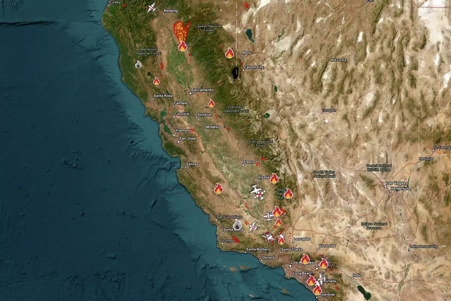
Map shows where large wildfires are burning in California right now Map of Fires around California as of Sept. 10, 2024. Cal Fire By Amy Graff, Senior News Editor Sep 10, 2024  Multiple wildfires were burning across California on Monday, threatening communities and forcing people to leave their homes. The state is moving into a time of year when it usually sees its most destructive wildfires. In September and October, the vegetation on the ground is parched and highly flammable after a dry, hot summer. What's more, this is the time of year when offshore winds, which fan flames and cause wildfires to spread quickly, often develop. Here's a look at fires burning across the state: Time-lapse Alert: "Airport Fire" in Riverside County 🔥 Check out this powerful time-lapse video showing the #AirportFire east of Santiago Peak, captured by @ALERTCalifornia. California is still facing extreme fire behavior with high temps and dry conditions. Remember:… pic.twitter.com/Jz3pVdDFJR — CAL FIRE (@CAL_FIRE) September 10, 2024 Airport Fire, Orange County Started Sept. 9 9,333 acres, 0% contained The fire broke out in the eastern corner of the county in Trabuco Canyon, about 30 miles southeast of Anaheim. The first flames were reported near the Trabuco Flyers Airfield, where people go to fly remote control planes, which gave the fire its name. Trabuco Canyon and Rancho Santa Margarita are among the areas where some homes have been evacuated; get the latest information on evacuations and road closures from the Orange County Sheriff's Office. The cause of the fire is under investigation. Remarkable images from Santiago Peak fire cams as comms site there overrun by #AirportFire. Appears that cameras may have been within a few yards of a significant fire whirl... #CAfire pic.twitter.com/U6XWvzL5s5 — Dr. Daniel Swain (@Weather_West) September 10, 2024 Boone Fire, Fresno County Started Sept. 3 17,766 acres, 44% contained This wildfire ignited in western Fresno County near the Monterey County line on the outskirts of Coalinga, a Central Valley city of 17,000. "The fire has mainly been creeping and smoldering in rugged terrain within the fire perimeter. Crews continue suppression repair and work on establishing and strengthening control lines," Cal Fire said in a Tuesday update. Get the latest information on evacuations from the Fresno County Sheriff’s Office. The cause of the fire is under investigation. Boyles Fire, Lake County Started Sept. 8 81 aces, 40% contained This fire started and spread quickly in a populated area of Clearlake, a town that sits on California's largest freshwater lake. Forward progress was stopped on Monday. Flames have destroyed more than 30 structures and 40 vehicles, Cal Fire said. The cause of the fire is under investigation. #BridgeFireToday fire is currently 3,786 acres with 0% containment. As of 7:00 a.m. this morning, California Interagency Incident Management Team 5 assumed command of the Bridge Fire. For fire info visit InciWeb: https://t.co/VygQYbIEBG pic.twitter.com/QoOxEun7rn — Angeles National Forest (@Angeles_NF) September 10, 2024 Bridge Fire, Los Angeles County Started Sept. 8 3,786 acres, 0% contained Started in the Angeles National Forest, this fire is pushing east toward Mount Baldy, a popular area for recreation with a ski resort that straddles Los Angeles and San Bernardino counties. On Monday, an evacuation order was issued for "the area of Baldy Village from the dam to Baldy Resort," the San Bernardino County Sheriff's Department said. Evacuation information is changing quickly: Get the latest information from the sheriff's department. The cause of the fire is under investigation. Coffee Pot Fire, Tulare County Started Aug. 3 13,681 acres, 37% contained This blaze ignited by lightning has been burning in the southwest corner of Sequoia National Park for over a month. Firefighters built a containment line around it but then a tree engulfed in flames "rolled over the containment line, and the fire began to grow," Cal Fire said. While the park remains open, the Mineral King area is shut down to visitors and there are some road closures. Get the latest information from the park's website. [Incident Update] The #LineFire is now 26,426 acres and is 5% contained. A local🚩Red Flag Warning🚩 goes into effect in the area from 11:00am to 8:00pm. Today will be mostly sunny over the fire area, and the smoke impacts are expected to grow as the day progresses. LINE FIRE… — CAL FIRE BDU (@CALFIREBDU) September 10, 2024 Line Fire, San Bernardino County Started Sept. 5 27,974 acres, 5% contained The first flames were reported in the foothills just above the suburb of Highland, east of San Bernardino — and the fire quickly exploded threatening thousands of homes at the edge of the Southern California suburbs. In a Tuesday update, Cal Fire said 65,600 structures were threatened with 9,200 of those under evacuation orders and 56,400 under less severe warnings. The San Bernardino Sheriff's Department is the contact for the latest evacuation information. The cause of the fire is under investigation. |
98519
From: Skywise, [DNS_Address]
Subject: Re: Map shows where large wildfires are burning in Cali
URL: InciWeb
|
A source I like for fire info is InciWeb - https://inciweb.wildfire.gov/ Brian |
Responses:
None
98518
From: Rodney Boulderfield, [DNS_Address]
Subject: Re: Map shows where large wildfires are burning in Cali
|
Ever notice how the pyrotechnic and tectonic activities seem to follow each other around? |
Responses:
[98521]
98521
From: EMY1, [DNS_Address]
Subject: Yes; was noticing that!!!
|
I was going to post that the other day! Very Interesting. EMY |
Responses:
None
[ Earthwatchers ] [ Main Menu ]